Best Day Rides from Cairns North: the Josephine Falls and Cassowary Coast run
From ReviRide Cairns H-D
Where the Tablelands loop trades the coast for cool hill country, this ride does the opposite: it points you south down the Bruce Highway through a corridor of sugarcane, rainforest and the looming peaks of Queensland's two highest mountains, Bartle Frere and Bellenden Ker. It is an easy-rolling, there-and-back day built for swimming stops rather than switchbacks, ending at a beach where prehistoric birds wander the sand.
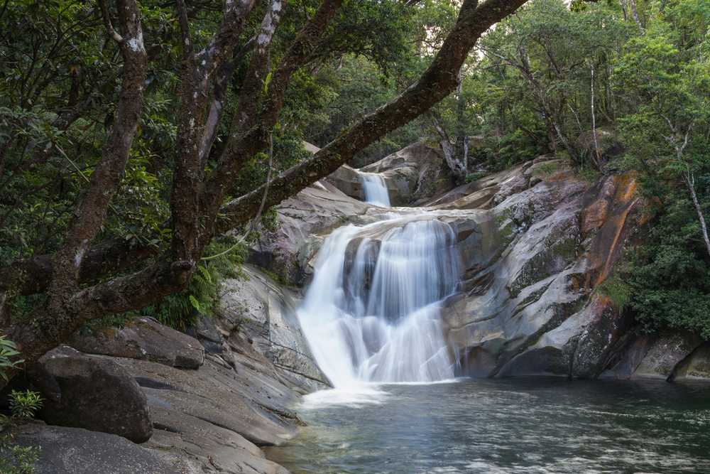
The headline act is Josephine Falls, tucked into Wooroonooran National Park at the foot of Bartle Frere. A short rainforest walk leads to multi-tiered granite cascades, clear plunge pools and a famous natural rock slide, all fed by some of the wettest country in Australia. It is one of the most-loved swimming holes south of Cairns, so an early start beats both the heat and the crowds.
String it together with the Babinda Boulders, a bakery lunch in a classic Queensland sugar town, and a final run out to Etty Bay, and you have a full day of warm water, deep green rainforest and that unmistakable Far North pace. Treat distances and conditions as a guide only, ride to the day you are given, and check the weather and national park alerts before you roll out.
Along the way
- 1
Gordonvale and Walsh's Pyramid
About 23 km south of Cairns, this sugar-mill town sits beneath Walsh's Pyramid, a striking 922 m free-standing peak that locals use as a homecoming landmark. A good first stretch-and-coffee stop before the open highway, with the Mulgrave River and cane country all around.
- 2
Babinda Boulders
A short detour inland from Babinda to a much-photographed swimming hole where Babinda Creek tumbles between smooth granite boulders. There is a calm day-use swimming area, free barbecues and the short Devil's Pool walk, though the river itself can be powerful and is signed accordingly.
- 3
Babinda township
A heritage sugar town famed as one of Australia's wettest, and a natural lunch halt. The Babinda Bakery is a long-standing favourite, with the historic Munro Theatre and small museums nearby if you want to stretch the stop.
- 4
Josephine Falls
The centrepiece. Turn off the Bruce Highway near Bartle Frere and follow the sealed road to the car park, where an easy walking track of roughly 700 m leads through rainforest to viewing platforms, lower swimming pools and the celebrated natural rock slide. Facilities include toilets, picnic tables and coin-operated barbecues; the top pool is off-limits for safety.
- 5
Golden Hole (Biggs Recreation Reserve)
Just a couple of kilometres on from Josephine Falls, this quieter day-use area on the Russell River offers picnic shelters, toilets and clear views up to the peak of Bartle Frere. A peaceful spot to picnic away from the busier falls car park.
- 6
Etty Bay
The turnaround and reward: a secluded white-sand cove south of Innisfail where rainforest meets the sea, reached by a short climbing road over the Moresby Range. There is a surf club, a caravan park and a cafe known for fish and chips, plus a genuine chance of seeing wild cassowaries strolling the beach and road.
Before you go
- Fuel up in Cairns before leaving; top up again at Gordonvale or the Mirriwinni and Babinda services, as options thin out on the smaller side roads and at the beaches.
- The Bruce Highway is fully sealed but carries trucks and has narrow lanes and occasional rough patches; use the marked overtaking lanes and plan turns early, especially the inland turnoffs to the falls.
- Josephine Falls and the local creeks are prone to sudden flash flooding. Heed the flood-warning system and safety signs, get out of the water immediately if levels rise or the colour changes, and never jump or dive.
- This is croc country in the rivers and estuaries, and cassowaries regularly cross the road near Etty Bay, so ride slowly through that final forested descent and never feed wildlife.
- If you plan to swim at Etty Bay during the November to May stinger season, stay inside the marine stinger net and between the flags, and carry sun protection and water for the humid coastal heat.
Ride it on a ReviRide bike
Helmet and 800 km/day included.
Routes are suggestions only. Roads, conditions, and access can change — check current conditions, ride to your ability and the conditions, and obey all road rules.